DEFENSE
Peter Fend
1. Exercise the 2nd Amendment: let citizens organized in “well-regulated militia” make use of civil-grade versions of advanced cyber and monitoring technology, with rights to alert their fellow citizens. The 2nd Amendment does not mandate that individuals buy and use guns on their own, or suggest that guns are suitable “arms” for “the security of a free State.”
2. Phase out nuclear weapons. A threat of their use prevents a genuine contest or decision: e.g., Korea 1951. They preclude the aim of conflict, deciding who controls territory, by making territory lifeless. They assure neither defense, nor freedom, nor survival. Their use in East Asia, an area of greatest risk, would contaminate the US West. Their use in Europe or the Arctic would destroy life on earth. Risks of nuclear conflict remain among Indian Ocean states. The US could reduce that by decommissioning. Spend $150B each year, for four years.
3. Remove the three main threats now to the US: (1) deforestation of the Amazon (put it under UNEP/UNDP control with indigenous habitation, fulfilling a papal edict of 1494); (2) mining for oil and uranium in Greenland (remove foreign companies busy there; declare Greenland to be our icebox); (3) air/water pollution (smog; Fukushima) sent from East Asia (speed up shift to renewable energy).
4. Place all missile and space programs in a Space Force. Treat any trip to a planet or moon as a military expedition, with colonial aims.
5. Make all military services able to survive on site. Navy ships produce energy from the sea and sun, in large tracts or as they move (as R&D’d already); Air Force jets burn bio-kerosene grown near bases (as Australia tested); Army deploys ultra-lightweight waterwheels and solar panels, instead of trucking fuel (as NZ starts in Afghanistan); Space Force relies on solar energy or hydrogen, both emissions-free.
6. In Africa and the Middle East especially, apply Earth Art ideas widely, as Russia already designed for Iraq in 1980-87, to un-do deserts. Thus restore the animal-rich savannah from long ago. We meet requests made by diplomats from Algeria, Iran, Iraq, Egypt—-after they viewed satellite studies of the Iran-Iraq war by a US-artists’ militia. Structures could move rivers, effect barriers, and win battles.
7. Control and build transportation infrastructure in the US. Rapid circulation within and between cities increases territorial strength.

First subject for Shadow Defense Secretary, due to WSJ news article on our first day, January 20, 2017. The site of bombing by two B-2s was studied by the Shadow Defense Secretary in Spring 1986. A record of this exists in the book “Ocean Earth,” including a drawing made in 1986 noticing a “gap” between the wadi (ephemeral river-bed) there and the Sea. An image of the air base, not showing the SAM-5 sites, was published in the International Herald Tribune article about Ocean Earth, February 26, 1986. The site is in the middle of a larger sea-basin concavity, that of the Gulf of Sirte and its immediate coastal outflow. The blue and green markings show sub-sea-level troughs near the Sea which Ocean Earth proposes to flood.

The WSJ news article, describing an attack from the stealth-bomber airbase in Missouri. The flight price alone was $4.4 M. The 100 bombs dropped cost ca. $1.4 M. Drones as well push the cost of the strike to $6 M. 80 ISIS soldiers were reportedly killed. The cost of each soldier killed is ca. $75,000. Very likely, using aircraft from an aircraft-carrier battle group would be more costly. Also, more risky, given that the SAM-5 missiles have worked against US aircraft over Libya. Further, with internet and monitoring tactics on shore, people opposed to US presence in the Mediterranean could readily expose any aircraft-carrier battle group. Iran has developed speed-boat swarms for attacking and sinking such large ships, much like what the Venetian gondolas, with their bow-blades, were able to do against giant Turkish warships.
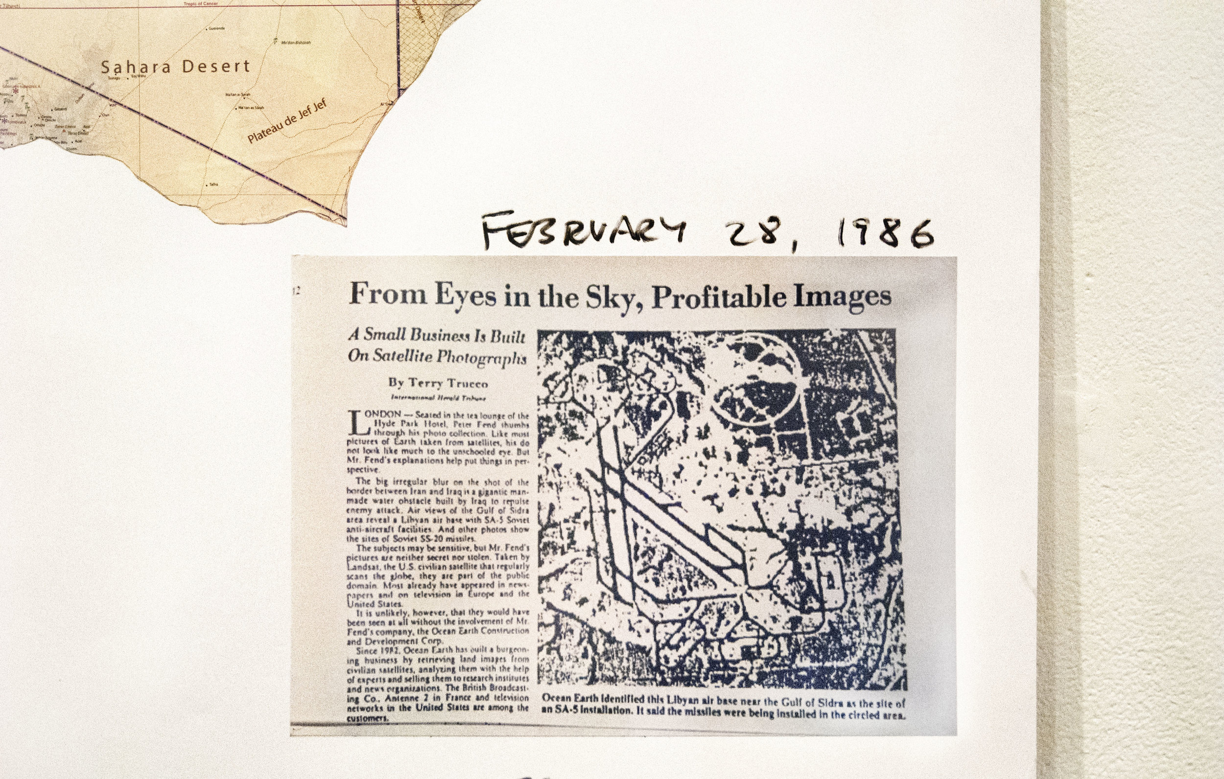
Excerpt of a news article from the International Herald Tribune (now the International New York Times), as recalled now, February 26, 1986. The article describes Ocean Earth and its president. It could have mentioned more people, such as the source of thinking that led to satellite monitoring at all, Taro Suzuki. Most memorable about the Libyan base study was how, in Rome, where the work was done, the press corps who had been on the USS Saratoga complained about seeing nothing, but this writer, having been in a satellite data-processing center, saw much more. Ironically, the article more harmed our ability to do business than helped; the spy agencies all swooped in.

Drawing made in Dusseldorf, Germany of the Sirte base and environs, with “Ocean-Earth Corporation” stamp, 1986. The gap between the main wadi (Talil) and the Sea is noted. A photograph of the site appeared in German, Italian and other press, and video footage appeared on TV news channels worldwide. The dendritic pattern within a Sirte Gulf basin was produced at about that time, with a JNC aeronautical chart (1:2,000,000), and appeared later in the book “Ocean Earth” (1994).

A more accurate study of wadis as they flow into the Sea to the east and west of Sirte. This is based on a 1:500,000 TPC aeronautical chart, with wadis named. Elevations are shown for above 750 ft and above 1000 ft. Encircled are wadi areas smothered in alluvia, or blocked by sand. They exist along the coast, and well inland. The Shadow Defense Secretary proposes that the coastal barriers be removed by crews of work- and food-hungry refugees, who’d finally earn a living. Methods have been tested with a similarly-blocked wadi near Dubai (see Bomb magazine, Dec 2011). The sites well inland, and some parts of the wadis now with braiding, could have troughs and craters bombed out by B-2 bombers. Those sites might as well have no people; a warning could be issued beforehand, to be certain. Such bombing runs - conducted for solely ecological and economic-development reasons, being restoration of water supply, even soggy lands - could win the adulation of the people there, native and refugee alike. Next in production: a study of all wadi-Sea sand-dune barriers in Libya, aimed at starting a massive work program for the refugees now there. This would be coordinated with macroalgae sea industry, for local biofuel. Command would come from freshly-trained Libyan Coast Guard officers.

A simple act of pulling out a political line-drawing map of the Middle East, which I have used as a template for works, and then marking up just WHERE the travel-ban is imposed, reveals that the travel-ban probably has nothing to do with Islam, or terrorism, or immigration. It has to do, as the markup shows, with arranging the region for military action.
Three of the travel-ban countries—Iran, Iraq, Syria—are being cajoled by Russia into sharing intelligence on stopping ISIS, okay, but more consequentially, for securing the route of a long-planned oil/gas pipeline from Iran through Iraq to Syria. If Russia succeeds, then it takes a huge chunk out of the Western control of Mideast oil secured with the end of World War One. This the US wants to prevent. Meantime, the US tries to secure the Red Sea better, meaning it must fend off anti-Saudi and hostile activity on both sides of the Gulf of Aden, being Yemen and Somalia, and it must also reduce threats from a long-time foe, Sudan. The US already took South Sudan away from Sudan, and has been pulling on the Darfur area to the West, so Sudan is understandably hostile. Libya is in turmoil, is controlled largely by ISIS and other hostile or outright renegade forces, so it will also be subject to military attack. The orange countries marked here simply are the targets for US military planners. All the white countries are not targets. One can propose ecological-restoration projects there, by the same US aircraft, as the “Art... circled sites.” The blue, being Sea, is also highlighted to indicate where the US has free range without permission by any State: it’s Navy area. Such a map is very likely now in the hands of US Navy officers in the region. Their freedom of maneuver is very separately in the Arabian Sea, with passage past choke points into the Red Sea and Arabian/Persian Gulf, and in the Mediterranean Sea. Probably no US warships will attempt passage in these days through the Suez Canal.